Live Earth is a real-time operational awareness platform for business intelligence visualization to help protect your people and assets whether you are a government organization or an enterprise business. We originally supported the US Military for a variety of complex mission-critical scenarios and today we also support state and local governments and enterprise businesses.
Live Earth is different than most maps because we are built from the ground up to deal with real-time streaming data that is changing rapidly over time. We collect streaming data from around the globe and make that available to you, with our data synchronization tools. We also connect to your local IT systems and databases to build a single common operational picture for all your operations in one place.
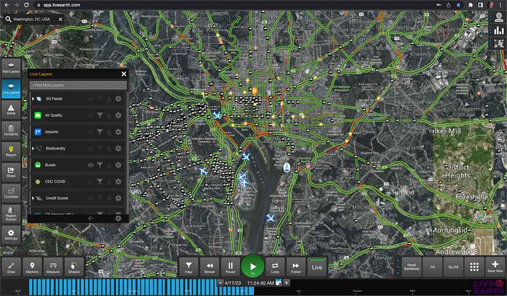
For example, you can see the Live Earth view of the Washington D.C. area and a variety of data feeds around the city, such as:
- A streaming traffic camera
- A city bus
- Road construction
- A building
- A ship
- A flight
These are all completely separate feeds that we have integrated into the Live Earth platform. We have aggregated them into the system, we sync them up in time and location, and then present them on the map. Now you have a complete picture of your entire city (or your area) on one screen. With our data visualization tools you can now monitor all these data sources live, and then we also record them as they come into the system so that you can go back and replay interesting events in the past.
The Interactive Timeline for Business Intelligence Visualization
From the bottom of the screen, users can roll the timeline back instantly. You will notice that the buses move in reverse, the flights move in reverse, and you will see the traffic changes.
If I want to go even further back, let us say several days, let us go back to April 10. The video now shows you April 10 at 7:20 in the morning and this is what D.C. looked like at that exact moment in time. This is where the locations of all the assets around the city were in relation to where my buildings were.
Real-time Alerts
Not only does Live Earth have an aggregation engine that brings all this data together, but the Live Earth platform also has an alerting engine. The critical alerts engine lets you know when interesting things happen within your data sources. Maybe you want to know when traffic drops below a certain speed in a certain area. Live Earth can trigger an alert when this event happens.
In this video, what you see is a square in the middle of the screen. This is a geofence. We have built a simple alert that says when a ship comes in or out of this box, let us know. All the yellow pins you see on the map are notifications of when a ship entered or exited that box. When an alert is triggered, I can also go back in time to the moment that the event alert was triggered and see what caused that alert to happen in the first place. In this instance, it is a ship. And we now know that the ship triggered the alert, and we also have its historical track.
Incident Management
Let us say your team has a special type of alert that you want to triage over time. We can also build an incident off an alert to keep track of special events to allow your team to work them over a period of time. Our incident management panel enhances business intelligence by showing all of the things that have been happening over the past day and any time a new incident comes into the system we drop it right here on top so that your team can always look at the top and see what’s the latest thing that’s come in.
In this example, we have set up an alert to monitor one of our Partners – the World Aware feed. They provide risk events around the globe. If you click on the incident, it will take you to that time, and that location, for that event. You can then assign it to someone on your team and add comments. This allows users to keep track of events over time and move them through a workflow to triage events.

